
RESOURCES SERIES: Earthquake-safe Buildings
ARTICLE 25 in a series of Educational Articles for Developing Nations to Improve the Earthquake Safety of Buildings
ABOUT THIS SERIES OF RESOURCES >>
The devastating 26 December 2004 Sumatra, Indonesia earthquake and Indian Ocean tsunami has intensified awareness of this oceanic earthquake hazard. Large stretches of coastline around the Pacific Rim and elsewhere are at risk of tsunami inundation. The destruction and loss of life from tsunamis is well documented in the histories of tens of villages and cities world-wide. A tsunami exerts large horizontal forces on any surfaces preventing its flow. Wood buildings offer no protection from tsunami, and stone, brick and concrete buildings may be destroyed at flow depths up to two meters, depending on the speed of the water.
The starting point for architects and planners in ascertaining the risk of tsunami is to obtain an inundation map of the area of interest (Figure 1). This information may be included in a seismic hazard map (Article 24). With an appreciation of the uncertainties and assumptions that affect the accuracy of such information, damage reduction measures can be considered. The number of options appears to be limited to the construction of tsunami walls or barriers, planting dense areas of low trees, and relocation. The Japanese have protected fishing villages by massive reinforced concrete walls. A very expensive option with considerable adverse environmental impacts, walls are far more effective than wide plantings. Although plantings absorb some of the tsunami energy, they also add to the volume of water-borne debris. Relocation of tsunami-affected settlements has been undertaken in a number of countries.
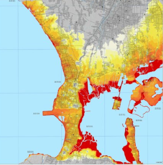
Figure 1. A typical tsunami hazard map, in this case of Bali. Darker colors indicate a greater probability of hazard (S. Wegscheider).
Tsunami early-warning systems and identification and provision of evacuation routes are also effective methods to reduce loss of life (Figure 2). But in some areas, tsunami flow can inundate low-lying coastal land many kilometers inland. With warning periods measured only in minutes there is nowhere safe to flee. For many such ‘at-risk’ people, what are termed ‘tsunami vertical evacuation centers’ are the only chance of survival (Figure 3).
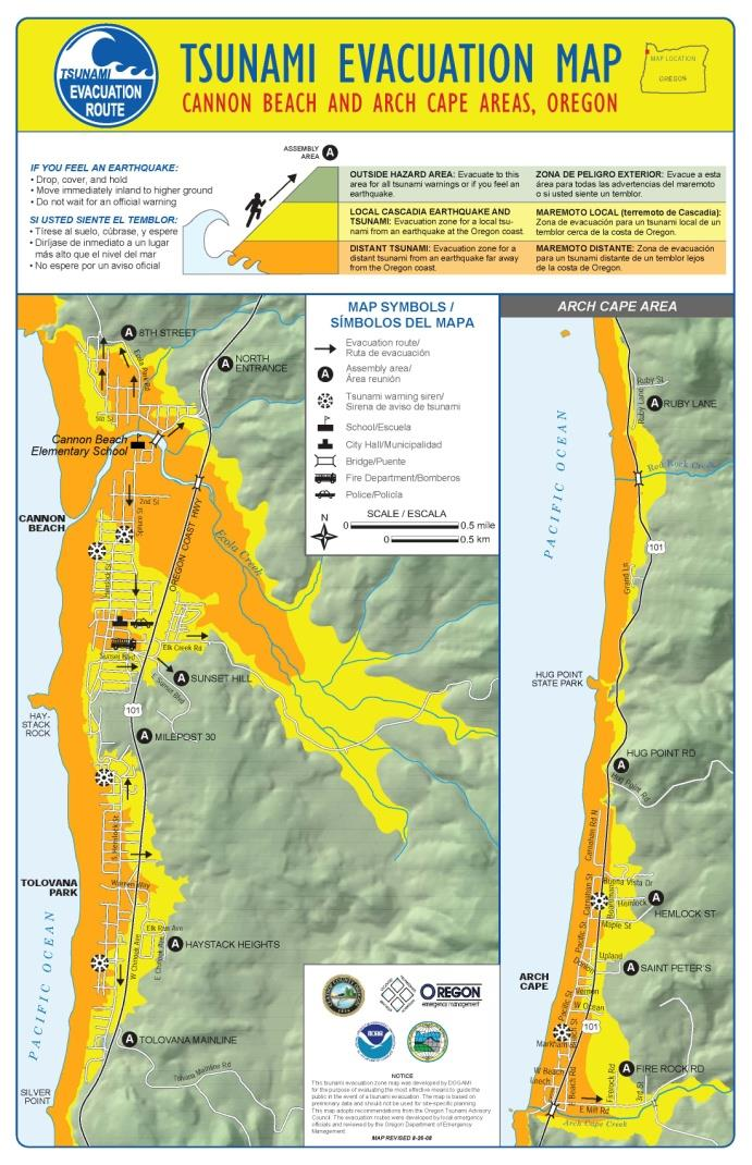
Figure 2. A typical tsunami evacuation map (Oregon State University).

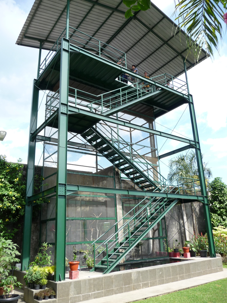
Figure 3. A private tsunami evacuation center. Most evacuation centers are for the nearby community.
The primary requirement of a tsunami shelter is to accommodate evacuees above the expected inundation level. As far as the structural design properties of a shelter are concerned, it must first be designed to resist earthquake forces from ground shaking. This means it must be designed to a higher standard than usual. It must also comply with every code requirement to ensure its earthquake safety. Then it must be checked it can withstand the considerable water pressures plus impact forces from water-borne debris.
References:
National Tsunami Hazard Mitigation Program, 2001. Designing for tsunamis: seven principles for planning and designing for tsunami hazards. https://nws.weather.gov/nthmp/documents/designingfortsunamis.pdf (accessed 16 June 2020).
Wegscheider, S, et al., 2011. Generating tsunami risk knowledge at community level as a base for planning and implementation of risk reduction strategies, Nat. Hazards Earth Syst. Sci., 11, 249–258.
<< PREVIOUS ARTICLE I
RESOURCES SERIES
INTRODUCTION:
About this resources series
- Earthquakes and How They Affect Us
- Avoiding Soil and Foundation Problems during Earthquakes
- Three Structural Systems to Resist Earthquakes
- Why Walls Are the Best Earthquake-resistant Structural Elements
- Are Walls in Buildings Helpful during Earthquakes?
- How Do Buildings with Reinforced Concrete Columns and Beams Work in Earthquakes?
- Principles for Earthquake-safe Masonry Buildings
- Tying Parts of Buildings Together to Resist Earthquakes
- Local Wisdom and Building Safety in Earthquakes
- Infill Walls and How They Affect Buildings during Earthquakes
- A Common Structural Weakness to Avoid: Soft Story
- A Common Structural Weakness to Avoid: A Discontinuous Wall
- A Common Structural Weakness to Avoid: Short Column
- Preventing a Building from Twisting during Earthquake
- Why Buildings Pound Each Other during Earthquakes
- Construction Codes and Standards
- What to Look for in Building Regulations
- What to Expect from a Building Designed according to Codes
- Importance of Checks during the Design of Buildings
- Importance of Checks during the Construction of Buildings
- Preventing Damage to Non-structural Components
- Retrofitting Buildings against Earthquake
- Advanced Earthquake-Resilient Approaches for Buildings
- Urban Planning and Earthquake Safety
- Tsunamis and Buildings